Rwenzori Mountains National Park is the highest and most dramatic mountain landscape in Uganda, a snow-capped range that rises straight from the equator and has fascinated explorers since the days of the ancient Greeks. Giant heathers dripping with moss, lobelias taller than a person, glacier-fed lakes, and jagged peaks wrapped in cloud make it feel like another planet. Known as the Mountains of the Moon, the range is a World Heritage Site and one of the finest trekking destinations in Africa, and Rwenzori Mountains National Park offers everything from a gentle day walk to a serious multi-day mountaineering expedition.
This complete guide explains how to plan a visit to Rwenzori Mountains National Park. We cover the history and geography of the range, the unusual vegetation and wildlife, the main trekking routes, including the Central Circuit and the Kilembe Trail, the shorter hikes for travellers with less time, the best time to go, fitness and altitude, how to get there, and what to pack.
At Afoyo African Safaris, we plan journeys through western Uganda from Kampala, so you will find practical advice alongside the facts, whether you want to climb to the glaciers or simply enjoy the views from the foothills.
About Rwenzori Mountains National Park
Rwenzori Mountains National Park lies in western Uganda, in the districts of Kasese, Bundibugyo, and Kabarole, along the border with the Democratic Republic of Congo. According to the overview of Rwenzori Mountains National Park, the park was established in 1991, designated a UNESCO World Heritage Site in 1994 because of its outstanding natural beauty, and later recognised as a wetland of international importance. The UNESCO listing for the Rwenzori Mountains describes the range as one of the highest and most spectacular in Africa.
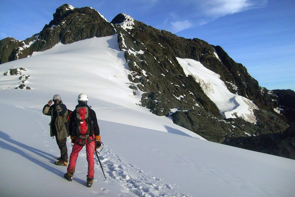
Unlike the volcanic cones of the Virunga region, the Rwenzoris are a block mountain range that was pushed upward within the Albertine Rift. The range stretches for about a hundred kilometres and contains six main massifs: Mount Stanley, Mount Speke, Mount Baker, Mount Emin, Mount Gessi, and Mount Luigi di Savoia. The highest peak, Margherita Peak on Mount Stanley, reaches 5,109 meters above sea level, making it the third-highest summit in Africa after Kilimanjaro and Mount Kenya. The park is managed by the Uganda Wildlife Authority, and treks are organised with community partners and trained guides.
Why They Are Called the Mountains of the Moon
The nickname comes from antiquity. The Greek geographer Ptolemy wrote about snow-capped mountains in the heart of Africa that fed the Nile, and he called them the Mountains of the Moon, perhaps because of their pale glaciers that glowed in the moonlight. For centuries, many people doubted that snow could exist on the equator, and the range remained a mystery to the outside world.
It was only in the nineteenth century that European explorers confirmed its existence, and in 1906 the Italian Duke of the Abruzzi led a famous expedition that climbed the main peaks and mapped the range. Today the glaciers are shrinking because of climate change, and scientists warn that they could largely disappear within the next few decades. That gives a visit to the high Rwenzoris a sense of urgency, and it is a powerful reminder of why conservation matters. Seeing the ice, even in its reduced state, is one of the great rewards of the longer treks.
The Vegetation Zones of the Rwenzori Mountains
One of the joys of trekking in Rwenzori Mountains National Park is the way the landscape changes as you climb. Each altitude band has its own plants, colours and atmosphere, and a single multi-day trek takes you through several worlds.
Montane Forest and Bamboo
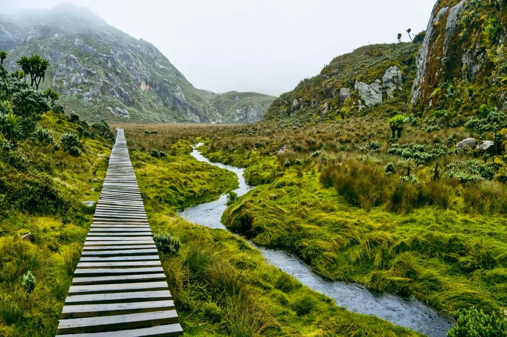
The lower slopes are covered in dense montane forest, rich in tree ferns, orchids, mosses and birds. Higher up, the forest gives way to a belt of bamboo, where the air is cool and the trail can be muddy. This lower zone is where most day hikes take place, and it is a good place to see monkeys and birds.
The Heath and Moorland Zone
Above the bamboo lies the most famous part of the Rwenzoris, a fairytale world of giant tree heathers draped in moss and lichen, with huge lobelias and groundsels that grow nowhere else in such size. Boardwalks and bogs make the going slow, and the scenery is unlike anywhere else on earth. This zone is wet and often misty, so waterproof clothing is essential.
The Alpine Zone and the Glaciers
Above about 4,000 metres, the vegetation thins to mosses, everlasting flowers and rocky ground, and the peaks and glaciers come into view. The high lakes are a striking blue, and the air is thin, cold and clear. Reaching the glaciers requires mountaineering equipment, a guide and a high level of fitness, and it is the final stage of the summit routes.
Wildlife in Rwenzori Mountains National Park
The Rwenzoris are better known for their plants than for large mammals, but wildlife is still rewarding. Chimpanzees, black and white colobus monkeys, blue monkeys and forest elephants live in the lower forests, though they are rarely seen on the main trails. Small animals such as the Rwenzori otter shrew and the three horned chameleon are special to the region, and butterflies and insects are plentiful.
Birdwatchers will find the range very rewarding. The park is part of the Albertine Rift, and it holds many endemic species, including the Rwenzori turaco, which is the park’s best known bird, along with sunbirds, francolins and bush shrikes. Early morning walks on the lower trails give the best chances, and a local guide can help you identify calls and shapes in the thick vegetation.
Trekking Routes in Rwenzori Mountains National Park
Several trails lead into the range, and the right one depends on your fitness, your time and your goals. All routes require a guide and are organised through the park’s community partners, and trekkers sleep in mountain huts or at campsites along the way.
The Central Circuit Trail
The Central Circuit is the classic Rwenzori trek and the most popular route. It starts at Nyakalengija, about twenty-two kilometres from Kasese, and makes a long anticlockwise loop through the heart of the mountains, passing glacier-fed lakes, moorland and the Bujuku Valley. It usually takes seven to nine days to complete, and a trek that includes the summit of Margherita Peak takes the same time or a little longer. The trail crosses the notorious Bigo Bog, a muddy stretch that can be hard going in wet weather, but many hikers regard the Central Circuit as the prettiest route.
The Kilembe Trail
The Kilembe Trail starts near the old mining town of Kilembe and is steeper and more demanding than the Central Circuit. It takes about seven to eight days to reach Margherita Peak and avoids the Bigo Bog, but the climbs are tougher and the huts are simpler. It suits experienced hikers who want a more challenging route and are comfortable with steep ground.
Shorter Treks and Day Hikes
You do not need to climb to the glaciers to enjoy Rwenzori Mountains National Park. Shorter treks of two to four days follow the lower sections of the Central Circuit, such as the route to Nyabitaba and John Matte Hut, and they give a real taste of the forest, bamboo and heath zones. Day hikes from Nyakalengija or the nearby Ruboni community offer views, birdwatching and cultural contact without the need for specialist gear. These shorter options are an excellent choice for travellers with limited time or fitness.
Climbing Margherita Peak
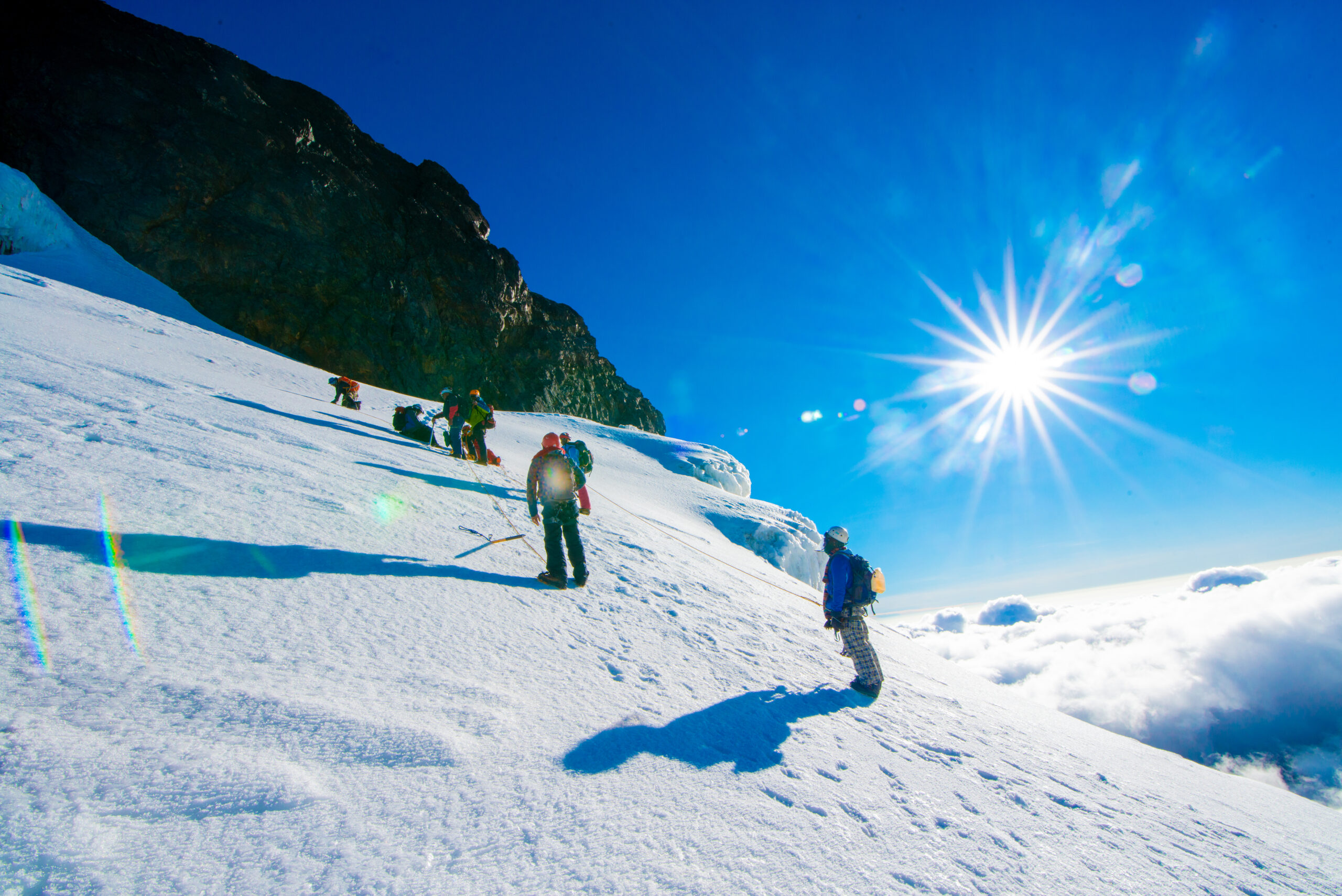
Climbing Margherita Peak is the ultimate Rwenzori challenge. The final ascent begins before dawn from a high camp, crosses glaciers and rock, and requires crampons, ropes and technical skill under the guidance of experienced mountain guides. Conditions can be harsh, with cold, wind, ice and thin air, and success depends on weather and fitness. It is a serious expedition that should only be attempted by those with proper preparation and a flexible schedule.
Fitness, Altitude, and Preparation
Trekking in the Rwenzoris is more demanding than most travellers expect. The trails are steep, muddy and often wet, the huts are basic, and the weather can change in minutes. A good level of general fitness is essential for the longer routes, and regular hiking, stair climbing and stamina training in the months before your trip will make a big difference.
Altitude is another important factor. The Central Circuit reaches more than 4,000 metres at its highest passes, and the summit of Margherita Peak is above 5,000 metres, so altitude sickness is a real risk. Climb gradually, drink plenty of water, listen to your body and tell your guide at once if you feel unwell. Talk to your doctor before a high-altitude trek, particularly if you have a heart or lung condition, and make sure your travel insurance covers trekking at altitude and emergency evacuation.
What a Central Circuit Trek Looks Like Day by Day
A typical Central Circuit trek begins at Nyakalengija, where you register at the park office, meet your guides and porters and set off through farmland and forest. The first night is usually at Nyabitaba Hut, after a steady climb through montane forest. The second day takes you across the Bigo Bog and into the heath zone, ending at John Matte Hut, where the giant heathers and lobelias begin to dominate the landscape.
The following days climb into the Bujuku Valley, past glacier-fed lakes and below the great massifs, with stays at huts such as Bujuku and Elena or Kitandara, depending on your plan. Summit attempts on Margherita Peak start well before dawn and return to the hut by midday, and the descent follows a different valley back to the lower forest. The final day is a long walk down to the trailhead, with a well-earned rest and a celebration with your team. Exact itineraries vary with weather, fitness, and the route chosen, so your guide will adjust the plan as you go.
Photography Tips for Rwenzori Mountains National Park
Photographers will find endless subjects in the Rwenzoris, from moss-covered trees to giant lobelias and glittering lakes. Mist and clouds create atmosphere, but they also hide the peaks, so be patient and ready to shoot when the cloud lifts. A wide-angle lens is excellent for the strange plant forms and sweeping valleys, and a zoom lens helps for birds and distant peaks.
Protect your equipment from rain and condensation with waterproof bags and silica gel, and keep spare batteries warm inside your jacket because cold drains them fast. Early morning often offers the clearest views, so a dawn start is rewarding. If photography is a main goal, our photography safaris can be planned around the light and the pace you need.
Best Time for Hiking in Rwenzori Mountains National Park
The best times to hike in the Rwenzori Mountains are the two dry seasons, from December to February and from June to July, when trails are firmer, skies are clearer, and views of the peaks are most likely. Even in the dry months, the mountains create their own weather, and rain and mist are common, so you should always carry waterproof gear.
The wet seasons, from March to May and from September to November, make the trails muddy and slippery, and the Bigo Bog can become very difficult. Visibility is often poor, and some routes become unsafe. If you can only travel in the wet months, choose a shorter hike on the lower slopes rather than a high-altitude trek. For a wider overview, read our guide to the best time to visit Uganda.
How to Get to Rwenzori Mountains National Park
The main gateway to Rwenzori Mountains National Park is Kasese, a town in western Uganda roughly 400 kilometres from Kampala, a drive of six to eight hours. From Fort Portal, the journey to Kasese takes about ninety minutes through beautiful hill scenery. The Nyakalengija trailhead and park office lie around twenty-two kilometres from Kasese, and the road passes through villages and farmland with views of the mountains when the cloud lifts. If you want to save time, you can fly to Kasese airstrip from Entebbe or Kajjansi, which cuts the journey to just over an hour. Our fly-in safaris are designed for travellers who want to combine western Uganda destinations without long days on the road. Remember to arrange your visa early with our guide to the Uganda tourist visa online.
Because the park lies along the border with the Democratic Republic of Congo, check your government’s current travel advice for western Uganda before you travel, and read our honest guide on whether Uganda is safe. A good planner will explain current conditions and adjust your route if needed.
Costs of Hiking in Rwenzori Mountains National Park
The cost of a Rwenzori trek depends on the route, the length of the trek and the level of service. Typical costs include park fees, guide and porter fees, hut or camping charges, meals, transport to the trailhead and any equipment you need to hire. Longer treks cost more, and summit expeditions cost the most because they need technical equipment and more staff. Shorter hikes are much cheaper and can be added to a wider safari at modest cost. Fees are set by the park and by the community partners, and they are reviewed from time to time, so ask your planner for a detailed, up-to-date quote. A tailor-made price will list exactly what is included, and you should compare offers carefully, since cheaper packages may leave out porters, equipment or meals.
Where to Stay Around Rwenzori Mountains National Park
Accommodation near the park ranges from simple community camps and guesthouses to comfortable lodges with views of the mountains. The Ruboni and Nyakalengija areas offer community-run options where income goes directly to local families, while Kasese and Fort Portal offer a wider range of hotels and restaurants. A few upmarket lodges sit on the foothills, with warm rooms and sweeping views.
Plan to spend a night before and after any multi-day trek, so that you can start rested and recover afterwards. Ask whether your lodge can store luggage while you are on the mountain, and book early in the dry seasons, since rooms near the trailheads are limited. A good planner can match your accommodation with your trekking schedule.
Other Things to Do Near Rwenzori Mountains, National Park
The Rwenzori region offers much more than hiking. Queen Elizabeth National Park lies to the south, with game drives, the Kazinga Channel boat cruise and tree-climbing lions, and you can read about it in our complete guide to Queen Elizabeth National Park. Kibale National Park, near Fort Portal, offers chimpanzee tracking, and the crater lakes around Fort Portal are beautiful places for quiet walks and swimming.
Cultural experiences are also rewarding. The Bakonzo people of the mountain slopes have a rich tradition of farming, music and crafts, and community visits let you learn about their lives. Our page on cultural experiences explains how to include them in a safari. A trip to the Rwenzori region fits well with an itinerary such as our 8 Day Wildlife and Gorilla Safari, and you can see more ideas on our Uganda page.
What to Pack for Rwenzori Mountains National Park
Packing correctly is vital for trekking in the Rwenzoris, because conditions are wet and cold. Bring waterproof hiking boots with good ankle support, gaiters to keep mud out, and several pairs of warm, quick-drying socks. Layered clothing is essential, including thermal base layers, a fleece, a warm hat, gloves and a high-quality waterproof jacket and trousers. Trekking poles help greatly on steep and slippery sections.
Other useful items include a headlamp with spare batteries, a warm sleeping bag for the huts, a waterproof backpack cover, sunscreen, sunglasses and a reusable water bottle. Carry any personal medication, and consult a doctor about altitude medicine. For a general checklist, see our East Africa safari packing list, and add the extra cold weather items above.
Responsible Trekking in Rwenzori Mountains National Park
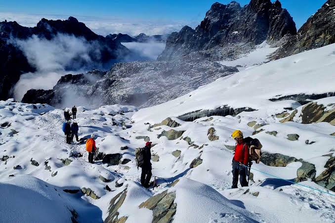
The high Rwenzoris are fragile, and the glaciers and plant communities are very sensitive to climate change and disturbance. Stay on the trail, carry out all rubbish, and respect the rules about camping and fires. Hire local guides and porters, pay them fairly and treat them with respect, since their knowledge and strength make the trek possible. Choose accommodation and operators that support community projects and conservation.
Tourism income helps pay for rangers, trail maintenance and community development, and it gives local people a reason to protect the mountains. For general guidance, the Uganda Tourism Board offers information for visitors, and your planner can explain how your trip supports local initiatives.
Frequently Asked Questions About Rwenzori Mountains National Park
Where is Rwenzori Mountains National Park?
It lies in western Uganda, in the districts of Kasese, Bundibugyo and Kabarole, along the border with the Democratic Republic of Congo.
How high is Margherita Peak?
Margherita Peak on Mount Stanley is 5,109 metres, the highest point in Uganda and the third highest in Africa.
How long does it take to hike the Rwenzoris?
Short hikes take one to four days, while the Central Circuit takes seven to nine days, and a trek to Margherita Peak takes seven to ten days depending on the route.
Is the Rwenzori trek difficult?
Yes. The trails are steep, wet and muddy, and the altitude is high. Shorter hikes are much easier, and you can enjoy the park without going to the top.
What is the best time to hike in the Rwenzoris?
December to February and June to July are the driest months, with the best chance of clear views.
Do I need a guide?
Yes. All treks in the park require an authorised guide, and porters are strongly recommended.
Can I combine the Rwenzoris with other parks?
Yes. The mountains lie close to Queen Elizabeth and Kibale National Parks, so they combine easily with game drives and chimpanzee tracking.
Plan Your Rwenzori Mountains National Park Trip with Afoyo African Safaris
Rwenzori Mountains National Park offers a rare chance to walk through ancient forest, giant heathers and high alpine scenery on the equator. Whether you choose a short hike in the foothills or a full expedition toward the glaciers, careful planning makes the difference between a hard slog and a rewarding adventure.
Our team at Afoyo African Safaris designs tailor-made journeys from Kampala, handling transport, lodges and guides so that you can focus on the mountains. Share your dates, fitness level and interests, and we will build a plan that fits. Plan your safari with us today and let us help you explore the Rwenzori Mountains National Park.